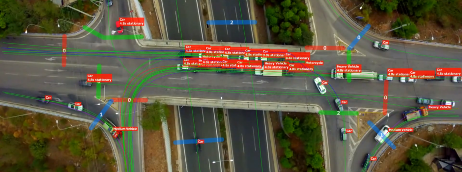
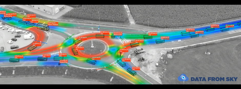
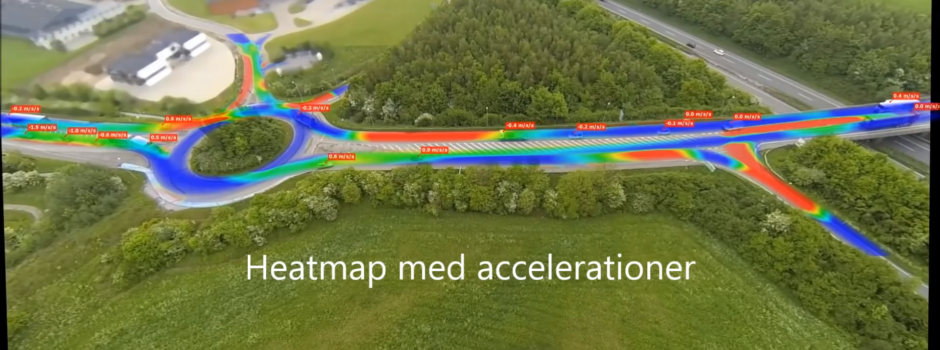
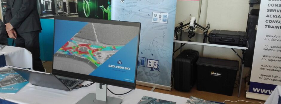
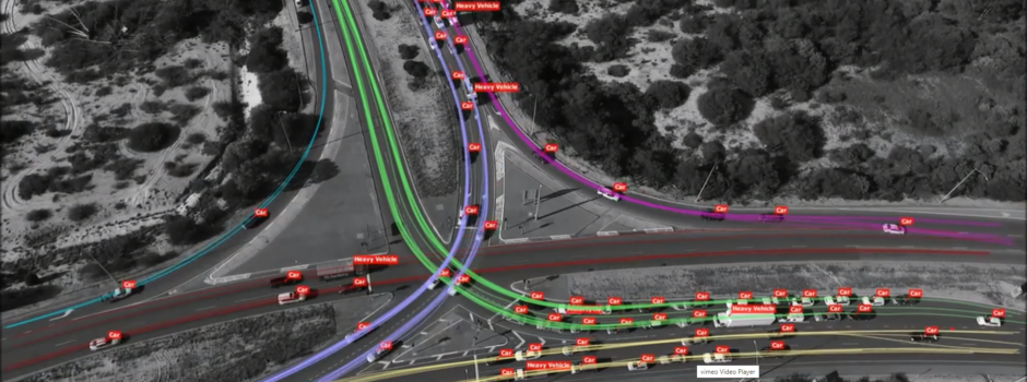
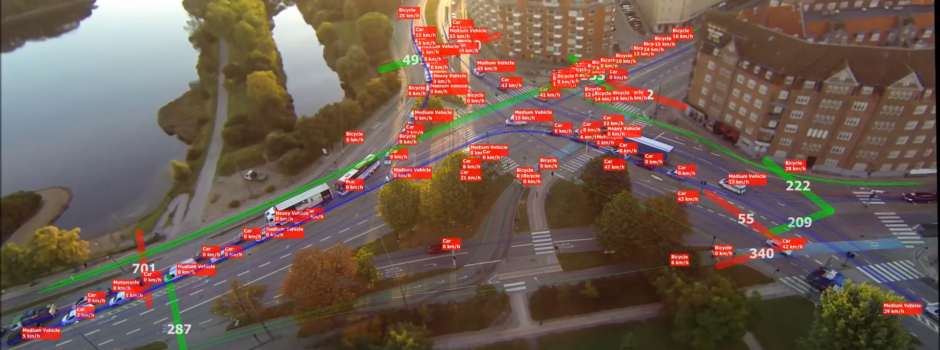
One traffic framework. Any video source. For all smart city tasks. All that smart traffic needs in the one solution – FLOW. The fastest and smartest way to get the traffic knowledge from any type of video stream that smart cities love.
Have you ever wondered how much data passes through DataFromSky? Are you interested in how many objects have been tracked and what distances are involved? We gathered some statistics for you! Here are the numbers for last three months:
35 234 546
meters of trajectories
391 494
tracked objects
230
hours of video
8
countries
2 251 090 500
detector hits
1 957 470
total length of tracked vehicles in meters
87.92%
portion of equator traveled by tracked vehicles
736
kWh burned for computations
What about the software itself?
DataFromSky is written in C++ language and, of course, based on OpenCV library and Qt Toolkit for frontend. The backend detection and tracking algorithms are accelerated by CUDA technology. Here are the numbers:
> 4 000 000
vehicle picture samples
180 000
lines of code
5 500
functions
405
classes
All of these numbers are growing! We are processing new videos every day, teaching the system on more examples of vehicles. We continuously improve our models for position calculation as well.
PS: In the near future, you can expect significant improvement in stitching of videos from more drones.
For the fourth consecutive year the DLR (Institute of Transportation Systems) held at its headquarters in Berlin the conference of SUMO (Simulation of Urban MObility). It is an open-source simulation platform implemented in C++ which allows modelling intermodal traffic systems including road vehicles, public transport and pedestrians.
The flexibility and the continuous development of computational models and new system features make this platform suitable for integration with other applications. Information sharing and the presentation of new usage scenarios involving this platform are some of the main reasons of its rapid development and growing success.
This year’s conference, that took place on 23-25 May 2016, was attended by numerous technicians of the transport field coming from European and American countries. DataFromSky was present, too, in order to expose a project being pursued in cooperation with the Italian partner Andrea Marella, entitled ‘Implementing traffic simulation model with aerial traffic surveys’. You can download the poster here:
The aim is to exploit the potential of DataFromSky, in terms of quantity and quality of gathered data, to improve and come up to a more realistic simulation scenario with SUMO. More specifically, the study has focused on the collection of dynamic data of passing vehicles on the survey stretch: this has allowed us to more accurately define the parameters that influence the driving behaviour of the users in that specific environment. The obtained characteristics are then used to define the simulation parameters for the car-following model, and then highlight the huge improvements in terms of virtual representation of the actual observed traffic behaviour.
Training course in Trieste
As we announced a few weeks ago, an interesting training course entitled “Methods and techniques for the monitoring and management of road traffic” presented by Eng. Andrea Marella (Trafficlab) was recently held in Trieste. The organization of the event was made possible thanks to the collaboration with the University of Trieste and the Order of Engineers of Trieste.
The meeting was attended by about 70 participants, road and traffic engineers most of all, who have joined with active interest and participation. During the 4 hours course have been described the innovative tools that are currently developing in recent years for the gathering of traffic data. Finally, the opportunity of the meeting has allowed to present a practical case of DataFromSky application, regarding the study of an intersection in Trieste from a video shot from the top of an high-rise. This analysis, already mentioned in previous news was the topic of master’s thesis “The Design of Road Intersection“ of a civil engineering student from University of Trieste.
The great success of the event confirms the interest in this field. Our hope is that other initiatives of this type may in future be promoted by engineering associations and universities, in order to provide an increased awareness of such instruments and of the great potential that they can offer.
DataFromSky and RCE appeared in Czech TV last thursday! We were covered as part of Cesty k úspěchu (Ways to success) – a series about new successful Czech entrepreneurs, currently in 11th season. The series is produced by Prima TV and sponsored by Komerční Banka. Marek Vašut, a popular Czech actor, is doing the interviews.
At the series’ website is a loose transcript of the interview (Google translate). A few parts are missing, though – eg. the funny relationship between founders: Aleš was supposed to teach David at a robotics course, but the actual flow of knowledge was not unidirectional. That’s when the idea of starting RCE Systems appeared first. DataFromSky came later.
As before in Denmark, logos are dutifully blurred by the broadcaster, but you can see our footage and the interviewer openly mentions DataFromSky.
Good Drone Lab at University of San Diego published recently an interesting open access “book” titled “Up in the Air: A Global Estimate of Non-Violent Drone Use 2009-2015“. The report is inevitably US-centric due to use of English language news as data sources, but there are several interesting facts listed in the book.
The two distinct questions the researchers asked are: (1) what is the nature of civilian drone use over time, and (2) what regulatory responses exist to use at the international, state, and sub-state levels. Some of the key findings are:
The year 2012 was a breakout period that saw non-military use overtake military use.
Commercial, emergency services, health and public safety, and environmental conservation sectors are growing.
Legislation is sparse and uneven, but growing.
Most regulations focuses on controlling weight, altitude, distance, no-fly zones, and operator certification.
There is no consensus policy on non-military drone use.
One thing is clear, commercial use is skyrocketing and does not seem to be slowing down any time soon.
Another recent development comes from the US National Telecommunications & Information Administration (NTIA), who arrived at a consensus regarding privacy guidelines for drone use. The resulting material was published under the name “Voluntary Best Practices for UAS Privacy, Transparency, and Accountability“.
The very characteristics that make UAS so promising for commercial and non-commercial uses, including their small size, maneuverability and capacity to carry various kinds of recording or sensory devices, can raise privacy concerns. (…) Operators should use this technology in a responsible, ethical, and respectful way. This should include a commitment to transparency, privacy and accountability.
The published material contains a number of concrete recommendations. The voluntary best practices encourage UAS users to:
inform affected persons of UAS use and the collection of data;
take care in the collection and storage of information that identifies a particular person;
limit the use and sharing of such data;
secure data; and
monitor and comply with the law as it evolves.
This topic resonates strongly with what we learned about use of aerial video as our business grew, and thus may be of interest to our readers and followers. Some of the privacy concerns are mitigated by the resolution of video that we collect. Arguably, it is impossible to identify people and vehicles since faces and number plates are less than 10 pixels. Of course, combination of the video with other data source is possible.
A more pressing concern is that video from above allows us to see otherwise private places such as walled-in gardens, backyard, roofs, patios… In response to this, we added anonymization functions. We handle videos sent to us with care and use encryption to allow only key team members unrestricted access to complete imagery, when needed during processing.
For the rest, such as informing the people in the area, we rely on the operators collecting video.
Both the PTW driver and the driver of the vehicle being overtaken are assumed to be rational decision-makers that develop strategies, while commuting in urban environment, trying to get the best outcome for their decisions. These strategies may be cooperative or not based on both drivers’ choices with respect to the distances and safety gaps they leave from the lead vehicle. Since PTW follow unorthodox trajectories, especially in an urban arterial, having detailed naturalistic data is essential, and this is how DFS comes in handy!
We are always looking for partners from academic sphere. Are you a researcher in traffic or civil engineering? Don’t hesitate to contact us! This video is an excerpt with no motorcycles present. You can see some new features of the Viewer: a lateral acceleration heatmap, distance measurement, and a testing bounding box makes a guest appearance too. Heatmap overlay is a completely new feature: When activated, you can configure it to display a scalar value. You can currently select from various speed, count and acceleration types of quantity. The color map and its value range are configurable as well. References:
Barmpounakis, Emmanouil N., Eleni I. Vlahogianni, and John C. Golias. “A Game Theoretic Approach to Powered Two Wheelers Overtaking Phenomena.” Transportation Research Board 94th Annual Meeting. No. 15-1425. 2015.
Barmpounakis, E.N., Vlahogianni, E.I., & Golias, J.C. (2016). Intelligent Transportation Systems and Powered Two Wheelers Traffic, IEEE Transactions on Intelligent Transportation Systems, 17(4), 908-916. http://doi.org/10.1109/TITS.2015.2497406
Barmpounakis, E. N., E. I. Vlahogianni, and J. C. Golias. “Vision-based multivariate statistical modeling for powered two-wheelers maneuverability during overtaking in urban arterials.” Transportation Letters: The International Journal of Transportation Research (2015): 1942787515Y-0000000020
DataFromSky has in COWI an exclusive partner in Denmark and other Nordic countries since March this year. COWI’s use of drones for traffic data collection and analysis using DataFromSky has been now covered by DR, the Danish national broadcasting company. In prime time, no less!
You can watch the evening news video. The drone part starts at 6:13. Apart from showing the drone operations and interviewing various officials (all in Danish), you can see a beautiful example of DataFromSky footage there, too – although with all branding zealously removed except for the television logo. The effect of now-implemented and released anonymization is plainly visible there nicely: In the TV low picture quality it looks almost as tilt-shift photography. This is also an opportunity to take a closer look at some real hardware used practically daily for traffic analysis recording.
COWI mentioned this on their City Creators blog in article Droner flyver ind på nethinden (Drones fly into the view), where they previously introduced DataFromSky. They also mention that the commercial drone sector could employ as much as 15 thousand people just in Denmark – whether that figure also originates from the news video we do not know.
Czech articles
An article titled “Světová stopa mladých českých podnikatelů” (The World footprint of young Czech enterpreneurs) was published by the startup competition Nastartujtese.cz across various media, both online and in print. The article showcases the top 3 projects of the last year’s copetition (we were second) and invites submissions to this year’s round. It’s great that traffic safety is taken seriously and that we are among the Czech companies that leaver some impact on the world.
The two immediately reachable versions of the article are these by Podnikatel.cz and Peníze.cz, both in Czech. The article is scheduled to appear in print media within a few weeks, too.
DataFromSky technology has added new possibilities to transport and road fields. It highlights a great need of people working in these fields – to be equipped with adequate tools for conducting surveys and collecting data. The purposes for which such data is collected places severe requirements on precision and reliability. Choosing the right methods and devices used for traffic monitoring and vehicle counting is a question of selecting the best ones for a given environment.
All of this will be part of discussion in the seminary with title “Methods and techniques for the monitoring and management of road traffic” presented by Eng. Andrea Marella (Trafficlab) and Eng. Erik Sferco (Trieste University), that will take place on Monday, 16th May at the Trieste University.
Program for the whole day is available in the following link, with an explanation on how to participate for those interested.
A few weeks ago, our Italian partner Eng. Morini from society TAU participated in a meeting day with theme “Advanced applications in road planning: survey and analysis of the traffic and the video images produced by Unmanned Aerial Vehicle (UAV) and “Big data” dataset obtained from cellular networks”, where he spoke about “advanced systems for survey and analysis of traffic and mobility in urban and suburban areas by processing of video images recorded thanks to flight and aerial platforms”. More information about the event is available at the following link (Italian only):
The rising interest shown by universities and official engineering associations demonstrates the growing confidence in DataFromSky and understanding what it is. We hope that these meetings could let traffic technicians know how powerful and innovative tool we are working on.
Diving into the wealth of charts accompanying the Commission’s press release, it is clear that the EU is divided between west and east in this regard, too. Should the eastern part somehow catch up, the targets would look far more reachable. Yet more alarming part of the statistics is that the vulnerable road users – pedestrians and bicyclists – saw hardly as much of improvement as vehicle occupants. Worth mentioning is that the statistics related to injuries have started being reported in a common format, which will enable better tracking of these injuries. The various sources mention several ways forward, including passing new legislative – increasing protection of vulnerable road users and revisiting the 2008/96/EC directive on infrastructure. The ETSC specifically calls out delays to a number of such changes as critical. Apart from these, cooperative ITS is mentioned, and Violeta Bulc, EU Commissioner for Transport, adds promotion of self-driving vehicles. At DataFromSky, we take safety seriously, especially that of vulnerable road users. We are steadily working towards making our services and products better to help understand road users’ interactions – not just for vehicular traffic, but others too. We too hope that technology can contribute to these efforts. We do not mean better cars, however. Better understanding of what happens on the road, using methods exploiting IT and otherwise austere with physical resources: that is what we hope for – and what we bet on, too. Sources:
We would like to announce a new great feature – reports that can be opened in the most widespread spreadsheet editor of all time (so far). Yes, Viewer can now export a complete Excel sheet listing all the possible things you want to know, starting with turning movements and ending with with an image of the annotations. If you do not use Excel, no reason to be sad – the reports are completely readable in LibreOffice, too, and probably in most other spreadsheet editors.
As an example, here is a video from EXPO Milano. Not exactly from the exhibition though, rather from a nearby roundabout during afternoon. This is another video shot from a building, this time at a very poor angle – one of the legs is completely hidden. You can see easily that the roundabout is severely congested in the first few minutes of video. Looks like an overhaul might be needed…
The video included here is a short example, the total recording includes over sixteen hundred vehicles. Anyway, you are invited to take a look at what an excel report from such a place looks like:
EFLA, an engineering company from Iceland, asked us for a demo of DataFromSky. They selected a roundabout in Selfoss, a town in Southern Region which is its administrative center. Its growth started after construction of a bridge over the river Ölfusá – the bridge that you see in the video is its later replacement. The roundabout also lies on the Icelandic Ring road. In this demonstration survey, we tracked 300 vehicles which travelled 57 893 meters in total, averaging 193 m per vehicle. The average speed was 27 kph. All commercial use of DataFromSky in the Nordic countries is handled by COWI, and key personnel can be contacted directly:
The necessary cookies are necessary for the proper functioning of the website and their use cannot be disabled. These cookies do not participate in any way in the collection of data about you.
Preferential cookies primarily serve to make your work with the website more pleasant. We use it to be able to display relevant information (eg. recommended articles) on the site.
Analytical cookies help us measure website traffic and events on the site. We then evaluate this data as a whole, ie. we do not use them for your identification.
We use marketing cookies primarily so that we can show you ads relevant to your interests that will not bother you. By enabling these cookies, you will enable us to make your work with the website more pleasant.