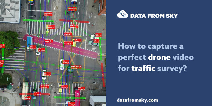
DataFromSky is a cloud-based platform for fully automated traffic analysis from videos using AI and machine learning methods. The output of the video analysis is an extract in the form of classifications of trajectories. This extract is then analyzed for various traffic tasks with numerous analytical functions it offers, fully interactively. Why is DataFromSky so unique:
● Super-accurate data suitable for traffic research (read more)
● Possibility of measuring a range of advanced parameters thanks to the trajectory-based approach
● Impeccable control of outputs thanks to extreme detail in displaying and simple export of results
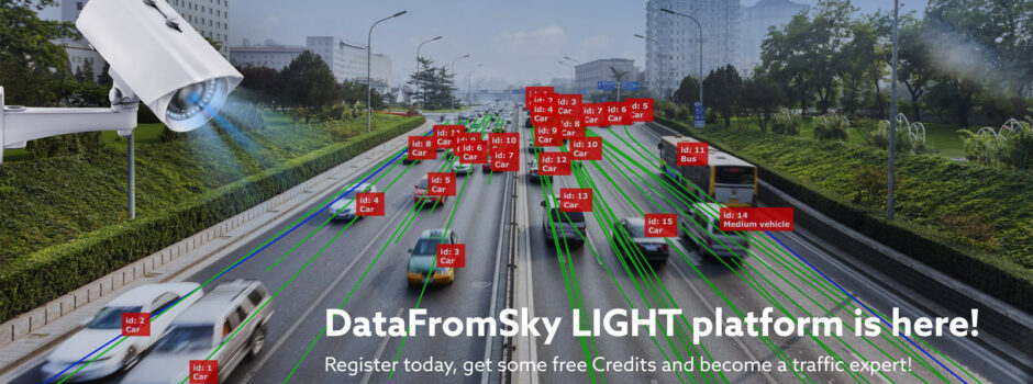
DataFromSky is composed of two advanced platforms — DFS LIGHT and DFS AERIAL. The AERIAL platform serves for traffic analysis from the bird’s eye view, using the state-of-the-art technology in the microscopic view on data. LIGHT version serves for standard traffic research in mass-scale using fixed cameras and numerous functions from the AERIAL platform. Both versions of DataFromSky have their real-time versions thanks to the series called DataFromSky Embedded.

Created for research, developed for traffic studies
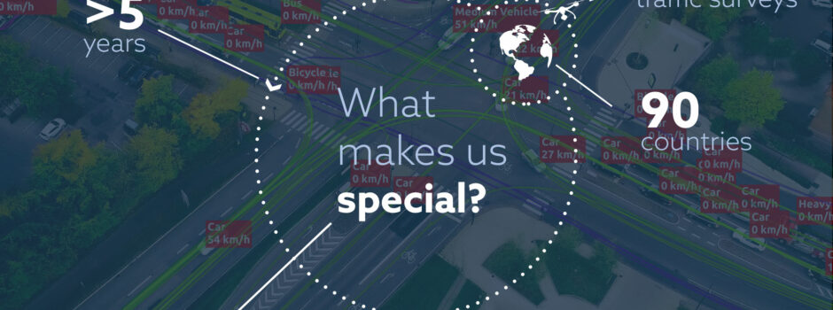
Development of the system started as a part of a research project in cooperation with BUT in 2013. The goal of the project was to use drones and advanced image processing algorithms to develop a new approach in the field of traffic analysis based on extracts of trajectories within the image. Thanks to its extreme accuracy, this project made brand new research goals, even those thought to be not feasible at that time, possible. The main aim of the project was to test the ability to localize ground objects with accuracy less than 25 cm from a drone with camera, which is suitable for advanced traffic analysis such as security audit, calculations of intersection’s capacity, research of interactions between individual participants of the traffic flow, etc.

The project entered the market under the name of DataFromSky and this allowed for further dramatic development and creation of a solution that is unique worldwide and already used in hundreds of research projects. From the very beginning, DataFromSky aims at solving the most challenging tasks in the field of traffic analysis. It is a software-based on scientific research and unique know-how, as it is constantly improving with sensitivity analysis of the system and numerous simulations as well as measurements within the real traffic. DataFromSky has by far the largest database of traffic behavior from places all around the globe, thanks to analyzing thousands of intersection nodes with extremely detailed data. Such a database background also guarantees the most advanced AI for these types of analyses, as our AI constantly improves with learning from the biggest database of traffic situations recorded with a drone, worldwide.
No black box solution
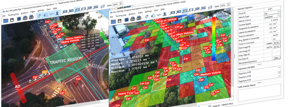
The philosophy of DataFromSky is to provide data that you can trust. This is the reason why it is based on possible highly detailed checking of the outputs of the analysis so that you can verify the accuracy of the automated analysis in a concrete video/place of yours. DataFromSky is not a black box solution, which would use only statistical data to hide the actual quality of outputs. It is actually the other way around, as with DataFromSky, you will have outputs displayed in a well-arranged and transparent manner so that you can easily evaluate the validity of data from the automated analysis. Always demand a possible control of outputs from detection algorithms for individual vehicles, as within the first five minutes of the video, you will already reveal potential system failure, which could consequently lead to an incorrect engineering decision. With DataFromSky, you have this option, as it stands on a philosophy that behind every good decision there are accurate data. No black box solution
Data is yours — no further payments
You can download a complete analysis to your own computer and store it, therefore you can come back to it at any time in the future and without any further costs. Outputs of the analysis can be accessed, viewed and worked with offline from any place even without the internet connection. To open and view the data, use our professional application called DataFromSky Viewer, which also offers a whole range of advanced analytics including displaying of results directly in the video. With supported “views” on traffic data, you can easily set various types of configurations of traffic analyses. Thanks to this interactive application, you will also be able to immediately react to any new emerging questions related to your traffic research even during the presentation of its outputs.

Need to add a new analytic function?
DataFromSky platform is constantly under development on all levels. If there is a specific type of export or a new type of analysis that needs to be added, let us know. We have already implemented tens of advanced functions on demand and incentive of our users, while some of them are still available. We have rich experience with the implementation of request from our clients in the field of traffic analysis, as we have been involved in numerous research projects already. As a DataFromSky user, you get not only super-accurate data, but also personal approach and professional support in order to successfully realize all your projects.
Real-time analytics — DataFromSky EMBEDDED
DataFromSky is not solely about post-processing. The system also embodies devices which allow transforming literally any camera into a smart sensor. We took the AI from DataFromSky and optimized it into the smallest processing units. This is how the DataFromSky Embedded series came into being. It is a platform from DataFromSky using the state-of-the-art processors with low input power, built for the operation of deep neural networks. Do you want real-time data? Do you want an adaptive system for traffic signal control within intersections? Do you want a smart camera? Ask for the DataFromSky Embedded series.

DataFromSky is a complex system for fully automated extraction of accurate traffic data using AI and machine learning methods. It has been developed and used for the purpose of traffic studies since 2013. DataFromSky AERIAL is a state-of-the-art and fully automated service for video analysis from the bird’s eye view (drones, balloons) for acquiring of super-accurate data not only for traffic research. DataFromSky LIGHT is a service for data analysis from low-altitude cameras for standard traffic research, fully automated as well. Try and see all the traffic magic FOR FREE!