The employment of drones and automatic image analysis offers new possibilities in traffic surveys, thanks to the accuracy of the measurement, the coverage range and the uniqueness of the obtained data. The camera is the most sensitive on the change of the position of ground objects in all directions when using the bird’s eye view. The dynamic occlusion between individual objects is minimalized as well.
These factual reasons together with advanced algorithms for extraction of traffic data ensure perfect information about every single participant of traffic flow.
Main aspects:
- Angle of recording/ drone position
- Lens speed / parasitic optical phenomena
- Resolution & framerate & bitrate
- Legislation
Angle of recording / drone position
In terms of accuracy of vehicle localization, the most ideal drone position is directly above the intersection — so-called TOP DOWN VIEW. At this position, the camera is the most sensitive to the change of the position of the object in the scene, therefore an extremely precise measurement of vehicle speed and acceleration is made possible. At the same time, the dynamic occlusion between individual objects is minimalized. Nevertheless, drone suspension directly above the traffic node is not always possible due to safety regulation and applicable legislation. In a situation like this, a simple rule applies — place the drone in such position that the view of the analyzed section is near to the bird’s eye view.
The procedure is as follows:
- Fly with the drone to the nearest possible place in the middle of the intersection.
- Ascend to the maximum possible height. However, do not cross the height where a pixel resolution of monitored objects would be less than 20×20 pixels.
There is a notable drop of the accuracy of the vehicle localization (please note that this does NOT hold for DETECTION or for CLASSIFICATION) if the angle of the view is higher than 55 degree.
A simple rule is as follows:
- Angle of incidence ˂ 55 degrees = the drone should always be higher than the distance between the projection of the drone position on the ground and the center of the intersection.
- 45 degrees means, that the drone altitude is the same as its distance from the center of the intersection.
- 0 degrees means that the drone is directly above the intersection.

The drone should always be positioned in that way so the dynamic and static occlusions are avoided. Occlusions increase the probability of failure of object tracking and of disengagement of continuous trajectories, in other words, one object will have a higher number of shorter trajectories. The systems are robust against short occlusions, but long occlusions can cause the disengagement of continuous trajectories into more parts.
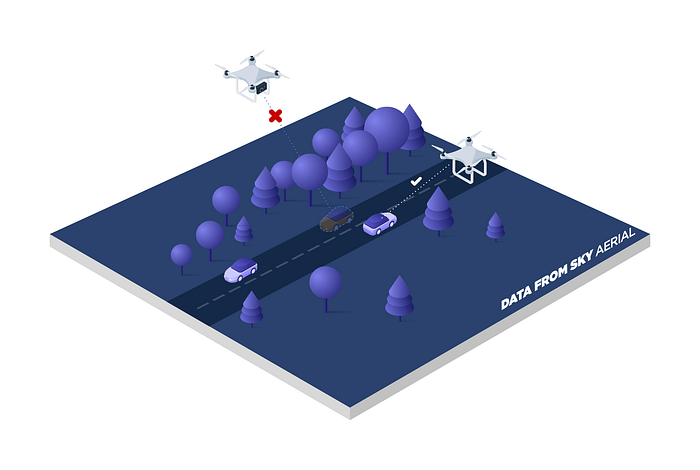
Try to keep the drone in the same position when recording. Do not change the drone altitude nor the camera take and zoom when recording. All parameters should have been set before the start of recording. For high-quality recordings, it is better to use a camera with ultra-wide range lens, not with fish eye lens, which causes high distortion especially noticeable at image margins.
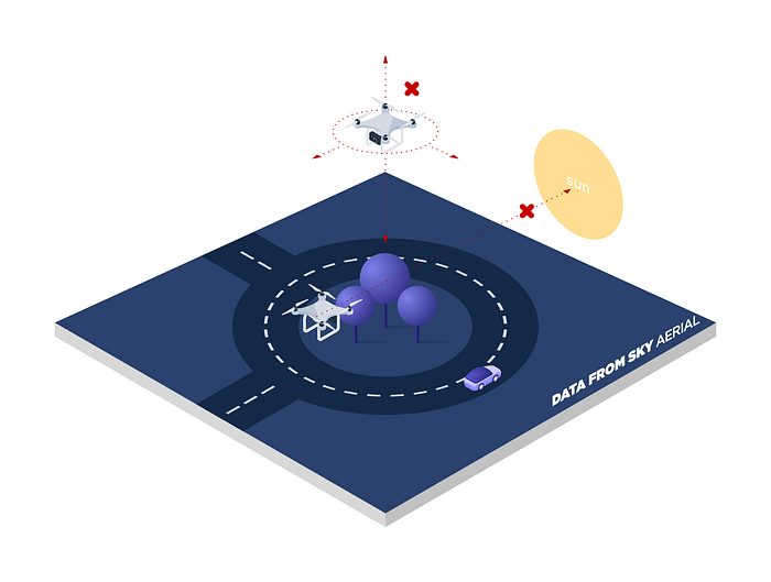
Parasitic optical phenomena / lens speed and scene acuity
When recording, try to avoid parasitic optical phenomena in camera take, which may be caused for instance by the sun or another strong source of light. Always turn the camera in such a way that this strong source of light is not recorded by a camera. Takes of scenes with sky should be avoided.
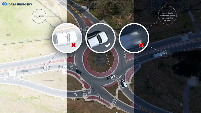
Focusing should always be carried out in such a way so the vehicles / objects are not blurred in a take. At the same try to set the camera in such a way so the objects are contrasting but not over-bright nor too much dark. This should be considered even at the expense of other parts of the shot. In case of night recordings or the recordings at the low light conditions, it is important that besides vehicles also the traffic elements are visibly identifiable.
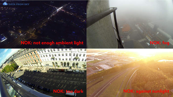
An image from camera ought not to be deformed by shaking (caused by drone motor vibrations) as a majority of cameras use the rolling shutter function to load image data in rows. If the vibrations are not sufficiently damped, their effect will occur in the form of shaking in between rows within the image. This shaking then lowers the accuracy of the used stabilization methods. Motor vibrations can be damped with suitable damping elements.
Resolution, FPS and bitrate
Resolution is a key attribute for the detection and classification of objects. The minimal size of an object within the image (for its detection) is 15×15 pixels, while for its correct classification, a resolution of 30×30 pixels is needed. A recommended size for objects within the image is between 30×30 pixels up to 150×150 pixels in the whole monitored area within the intersection. Object size depends on the following parameters:
- Image resolution
- Drone’s position — altitude / angle
- Mutual position of a monitored object and a drone/camera
A common rule is that if you record the video with maximal resolution used by modern cameras these days (e.g. 4K or 5K), it will be sufficient, as it is always possible to reduce the quality, but not the other way around. The following is a simple guide for resolutions:
- A distance with oblique angle < or = 120 meters -> FULL HD (1920×1200) resolution will be sufficient, but it is better to use a higher resolution (2k/4k)
- A distance with oblique angle > 120 to 300 meters -> use 4K video resolution
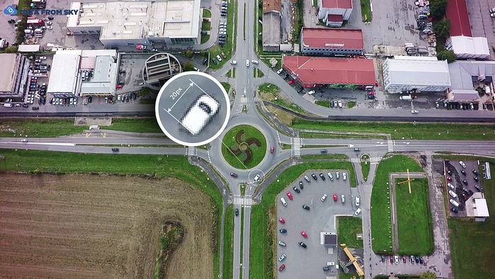
Framerate represents the sampling frequency of measurements. For vehicle speed up to 70 km/h, it is possible to use a framerate 15FPS. For vehicle speed over 50 km/h, it is better to use sampling frequency around 25 FPS. Sampling frequency over 35 FPS has no further positive effect on the quality of measurement, but only makes the video and its size unnecessarily large. The final quality of the video is also greatly influenced by bitrate settings. At FULL HD videos, coded with the H264 coding format, the bitrate should be at least 10 Mbit/s. At 4K videos, coded with H264, a minimum of 20 Mbit/s is necessary. The video must not be blurry, pixelated, or any signs of damage caused by compressing algorithms.
Tip for beginners: record video with 4K resolution and 25 FPS with standard bitrate (approx. 20 Mbit/s)
By following these rules you will get suitable videos for automatic processing to extract super-accurate data for your traffic study. Before the final recording, we recommend to carry out a test flight or make a few sample recordings in order to get acquainted with the basic principles. If you have any questions, do not hesitate to contact us.
Legislation & safety
Before the recording itself, always check what are the legal conditions for the recording of traffic in your country. Legislation differs from country to country and sometimes it is required to use services of a professional pilot with necessary permissions. There is also a predefined maximal flight altitude for drones in many countries (usually 120 meters), as well as a minimal safety distance (usually 50–120 meters away from objects). If the recording is carried out by a professional pilot, it is possible to gain permission even at different conditions. Always take the possible risks of technical failure into consideration.
If you do not want to carry out the recording by yourself, do not hesitate to contact us. We have a network of experienced and certified pilots all around the globe within the DataFromSky PILOT program. We will provide you with consultations about your project and its requirements in order to find the most suitable solution. We can also carry out the recording for you if necessary.
DataFromSky is a complex system for fully automated extraction of accurate traffic data using AI and machine learning methods. It has been developed and used for the purpose of traffic studies since 2013. DataFromSky AERIAL is a state-of-the-art and fully automated service for video analysis from the bird’s eye view (drones, balloons) for acquiring of super-accurate data not only for traffic research. DataFromSky LIGHT is a service for data analysis from low-altitude cameras for standard traffic research, fully automated as well. Try and see all the traffic magic FOR FREE!


