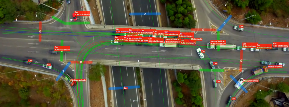
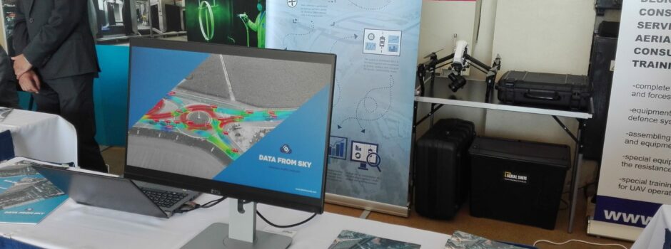
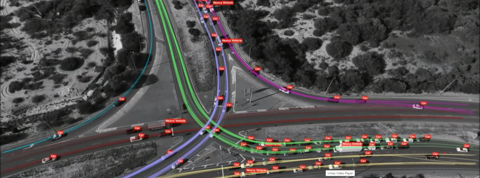
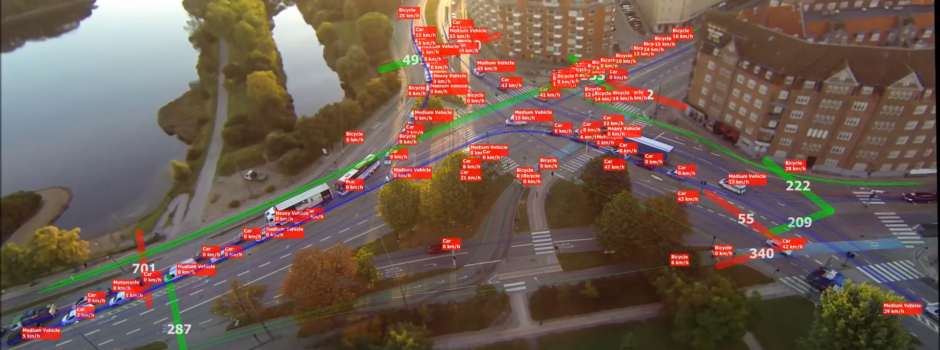
TrafficSurvey – Video post-processing platform

Let's meet!
Intertraffic 2024
16 - 19 April 2024
Amsterdam / Netherlands
Traffex
22 - 23 May 2024
Coventry / England
Let's meet!

Traffic Data Collection in Brazil

We worked on another demo video from Brazil, from Certare engenharia e consultoria. They perform a lot of turning movement and origin-destination counting. The camera was placed on a Phantom 3 professional from DJI, which was positioned perfectly over the area. It was one of the numerous junctions in Fortaleza, a junction of two one-way streets.

Traffic flow at the site is 2136 vehicles/hour.

Read more

Accuracy and error – model and measurements

If you follow our work for a longer time, you have probably noticed that so far we did not provide any exact numbers on accuracy and errors of the measurements. However, a method providing quantitative data without any quantification of its precision is somewhat dubious. Thus it should come as no surprise that we were working on these matters zealously behind the scene.

So, what do we have now? We have created a model of the whole process which generates our data, and we are currently working on a set of measurements to validate it.

Model

We have created a mathematical model of the whole process which generates our data. This includes the physical reality at target, complete optical system, and digital processing. The following error sources were considered:

  • landmark location errors (in meters)
  • landmark pixel uncertainty (in pixels)
  • camera intrinsic parameters (in pixels)
  • target pixel uncertainty (in pixels)
  • air turbulence (in pixels – included in target/landmark pixel uncertainty)

Using this model, we were able to relate together many variables of the setup – achieved accuracy, distance, covered area, incidence angle, slant range… The results were encouraging. The following picture shows area covered when using a 4k camera, depending on incidence angle and slant range, assuming maximal error of 0.5 meters:

Accuracy for a 4k camera, depending on incidence angle and slant range

What can one read from the chart? As you can see, the incidence angle of about 40° is a reasonable cutoff value. Slant range of 140 meters at 0° (i.e.: directly overhead) gives the best value. For a HD camera, the area covered is a quarter of that for 4k, and optimal altitude in zenith is halved – 70 meters.

We can also overlay the model’s predicted accuracy onto real pictures – that is, display achieved accuracy along with the footage. We hope to eventually incorporate that functionality into DataFromSky Viewer, so that you could check yourself. For now, we have this picture from the Randers video (in HD). Numbers are error in meters, with respective isolines displayed. A 4k video would yield half the error.

Achieved accuracy example in a real scene

Validation measurements

In order to validate the model, we made a set of measurements at a suitable place near Popice, a small Southern Moravian village known by the vineyards in the area.

Popice area used for measurements

We placed a regular grid of 64 landmarks in an 8×8 square pattern, so that a side of the square was exactly 100 meters. The landmarks were positioned using a professional GPS in differential mode, achieving placement accuracy of about 5cm.

Split picture: Calibration landmark, Jiří Apeltauer holding the gps receiver

Then, we set up an UAV to fly around and take a video, in 4k of course. Here is the trajectory projected onto ground, looking at the area from the west.

UAV trajectory projected onto ground

We simply imported the recorded video into DataFromSky and added the landmarks as tracked objects. You can’t see them in the picture because the red ID label “pin heads” are larger than an A4 at that resolution, but they are there.

UAV trajectory projected onto ground

Results

We are still working on processing the results. So far, the agreement between model and measurements is very good, and the model output suggests accuracy greater than we hoped for!

We will publish the results in an academic journal paper. Hopefully, the paper will be finished in a few days and we will be able to share more!

Since this text is about accuracy, we can hint that there is more to come: We measured the vehicle position using a vehicle-mounted dGPS as well, so there is be another set of data to work on.

Read more

Video from center of Charlottenlund, Denmark

Another video from Denmark analyzed, this time from a 4-way junction in the center of Charlottenlund and processed as a demo for WeFly. In slightly over 3:45, almost 140 vehicles pass, at an average speed of 10 kph. The traffic flow appears to be 2163 vehicles/hour.

There is a public school nearby, so there are a lot of student pedestrians in addition to cars.

The footage was taken on 20.11.2015 from the altitude of 57 meters. The camera used was GoPro 4 on a gimbal, recording in full HD at 50 FPS.

Map


Video

Read more

Brochure available online

A few days ago we mentioned the boxed version of our software. Design of its envelope is based on our print brochure, which we will give away at events, conferences, fairs, and whenever the opportunity arises. And you can now browse this brochure online to take a look!

It might be better to mention that the brochure is not exactly small, so it might take a while to load after you enter.

If you are a partner, feel free to grab a print-quality PDF version from the partner download zone.

Read more

DataFromSky mentioned by Brno U of Technology

Another Czech news about us! Brno University of Technology published a medium-length text about DataFromSky and Adam Babinec (in Czech – Google-Translation) at their news site. We are always happy when our hard work on DataFromSky is recognized, whether individually, collectively, officially or unofficially. We spent a lot of time working on DataFromSky in the last year, and hope to offer fruits of a lot more work this year. We’re looking forward to it!
Read more

Boxed version of DataFromSky Viewer is available!

We are pleased to announce that DataFromSky Viewer is available in a box version as well. And depending on your needs, this is not a bad option! Sometimes, a physical item is required. The box contains a DVD with the software, a printed user guide and DataFromSky brochure. Email, phone and Skype support can not be printed and put into the box, but are part of the deal, of course!

For more information about purchasing box version, please write to us at info@datafromsky.com or use our contact form.

Read more

Frame rejection in yet Another Denmark roundabout video

It’s time for yet another roundabout from Denmark! This time recorded in the city of Randers, using a tethered drone at altitude of 70 meters and processed as a 5-minute demo for COWI. Given that the drone’s range was 80 meters and it appears to be placed some 90 meters away, the result is certainly nice.

Frame rejection capability

Somewhat less nice is that the video has a few erroneous frames (images). So, we added function to fix that – marking frames as rejected for analysis. It does not mesh perfectly with all of the DFS parts yet: You may notice the background blinks (video problem) and that trajectories are smooth (data is cured), but somewhat confusing is that the labels themselves will jump (visualization breaks). Well, that’s a problem of display only, and will get better soon. The data is correct, that mattered as the first goal.

(Note also that since the web video player drops some frames on its own, you have about a 50/50 chance to even notice any single bad frames from the video below – you can try hunting for the one that occurs at about 0:50).

Statistics

Objects tracked: 220
Total distance travelled: 24314 m
Average speed: 10.31 km/h

Map

Video

Read more

Merry Christmas from DataFromSky

Everyone at DataFromSky would like to take this opportunity to wish you a Merry Christmas and Happy New Year! Thank you for all in 2015. We hope you have enjoyed it as much as we have!

Read more

Human convoy simulation tracked with DataFromSky

Researchers from Technical University of Brno recently had an interesting idea: Use a number of students to simulate a convoy with human drivers and measure the dynamics of that situation. To do so, they turned to DataFromSky, their trusted research partner.

It is no coincidence that DFS turned out to be a great tool for such situation – our long-term vision is to be the tool for spatial movement analysis. The students’ positions were marked manually; the rest of needed processing was already part of our software.

Enough rambling, take a look!

Read more

Master’s thesis about DataFromSky is one of TOP in Czech Republic

ACM SPY (Czech ACM Chapter & Slovakia ACM Chapter Student Project of the Year) is an official competition of high-prestige Czech and Slovak universities for the best master’s thesis in IT area.

One of our talented colleagues, Adam Babinec, was just chosen as one of TOP finalists in 2015 with DataFromSky thesis called: Traffic monitoring from aerial video data, and we would like to congratulate him! Keep fingers crossed for us in the announcement of final results.


dfs_adam_babinec

Read more