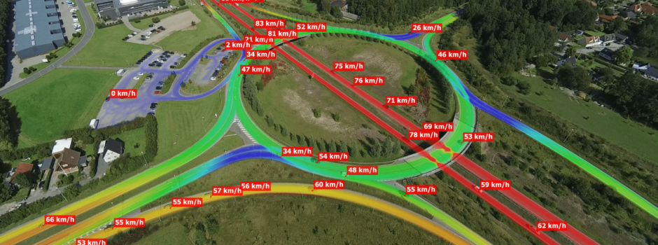
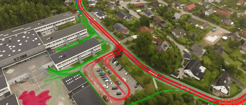
TrafficSurvey – Video post-processing platform

Let's meet!
Intertraffic 2024
16 - 19 April 2024
Amsterdam / Netherlands
Traffex
22 - 23 May 2024
Coventry / England
Let's meet!

Transforming aerial video data into knowledge

DataFromSky is a unique solution for motion analysis of aerial video data. The ability to detect, track and classify moving objects from aerial videos provided by drones, fixed cameras or other video sources opens new possibilities in the field of traffic monitoring. The technology behind is under intensive development and grows more efficient every day through the embedded capability of learning from its mistakes. We are happy to announce that we have made a significant step towards enhanced accuracy thanks to the complex integration of deep neural networks into DataFromSky framework. Our deep neural networks are being trained on millions of samples 24 hours a day. The quality is quite impressive right now!

Our tool for trajectory interpretation DataFromSky Viewer also comes with a new functionality. The new version extracts parameters which are sometimes difficult to obtain, such as gap-time, time to follow, heatmaps, and dimensions of vehicles. We recognize the potential of the data we are able to obtain, and, therefore, co-work on our tools with traffic researchers and traffic engineers worldwide. The video below demonstrates the new functionality of DataFromSky Viewer. Take a look!

Read more

Partnership with Elistair – tethered solution for UAVs

We are proud to announce our partnership with Elistair, from France, which has developed tethered solution for UAVs. Through this partnership, we can deliver a UAV solution for monitoring and analyzing of moving objects from bird’s-eye perspective. We are creating an unique access to unlimited aerial monitoring capabilities, for both public and private entities (traffic monitoring, perimeter security, etc.). We teach drones to see, to understand image data!
Read more

COWI demonstrates the possibilities of DataFromSky

COWI, an exclusive partner in Denmark and other Nordic countries, nicely demonstrates the possibilities of DataFromSky solution in a new video. In this video, you can see some basic outputs from DataFromSky Viewer such as speed & acceleration data, heatmaps, vehicle types etc. We have an endless list of functions that can be added or improved, so expect more to come!

All commercial use of DataFromSky in the Nordic countries is handled by COWI, and key personnel can be contacted directly:

Read more

DataFromSky at Seminar in Liberec – Deep Neural Networks

A Workshop titled Modern methods of image recognition and processing methods was organized recently by Technical University in Liberec. The aim of the workshop was to offer insight into image processing applications from the industry, as opposed to research setting.

We presented principles of detection and classification of vehicles from aerial video data using Deep Neural Networks. As you can imagine, Deep Neural Networks are integral part of DataFromSky platform and are used in many subtasks of DataFromSky solution. If you want to know more about the magic behind, you can download the presentation (PDF, 2 MB) and/or contact us.

Read more

DataFromSky participated at Day of Czech Aviation Industry

For the first time we have participated at Day of Czech Aviation Industry – an event dedicated to introduction and presentation of cutting edge technologies in the field of aviation industry and robotics. We demonstrated our capability to track moving objects in the aerial video data and slightly uncovered our own further plans related to perimeter security and online aerial monitoring. The event has been organized and supported by Ministry of Industry and Trade of the Czech Republic in cooperation with Association of Aerospace Manufactures of the Czech Republic and Defense and Security Industry Association of the Czech Republic.

Read more

New function – trajectory color by O/D matrix

We’re happy to announce another new function – coloring of trajectories according to O/D matrix. This feature completes the O/D coloring theme: You can now select to differentiate by color both the gate pairs’ highlights and individual trajectories.

In other news, DroneDeploy has recently released a report titled Commercial Drone Industry Trends. Predictably, the growth is exponential. Their data is primarily for their business, ortophoto maps – but the growth is spilling into other sectors.

Read more

Two years of DataFromSky

Recently, we celebrated two years since we started commercially! The DataFromSky team was formed shortly after starting RCE Systems as a robotics and computer vision company.

The decision to start offering traffic analysis using aerial video was a bold move, aiming for international market with a service instead of just contract work for Czech companies. The decision did pay off, though – we feel that at the moment we are the best in traffic analysis using UAVs, worldwide. Over the past two years, we kept growing: You can check the numbers in our earlier post, DataFromSky in numbers.

In case you are now confused about the names: DataFromSky is a service developed and offered internationally by the Czech company RCE Systems s.r.o.. You can check out some of the other things that we did contractually. Of course, only some of the projects are listed. We had the fortune of working with eg. Saab or Lasvit, just to name some.

In any case, we are busy with some new things for DataFromSky. Keep following us for more!

Read more

New: gate pair statistics and track colour by direction

Summer is a time for leisure, vacations and work pace is slower. DataFromSky did not completely sleep, though. Two new functions of the Viewer are now available!

This function is a generalization of origin-destination matrix. For an O/D matrix you need counts. DataFromSky can give you more, though: Instead of just counts, we also offer timing statistics – minimum, maximum, average and median plus standard deviation.

The Viewer got a new dialog for this. It shows a matrix of gates, and tabs for the various measures. When you select a cell, the pair of gates is highlighted as well as the path that vehicles take. If you select more, the highlight colours vary. This way you can easily look at the timings and see what belongs where. If the displays in image overlap, no problem – just drag them where they do not bother you.

direction colours 2 thumb

Track colour by direction

The second new feature allows you to visually discern what paths vehicles take, too. You can now set individual tracks (trajectories) to be coloured according to entry and exit gate combination. Thus you can easily see where a given vehicle goes, and if you select the non-present tracks to be visible, you can even see the paths all of these vehicles collectively take.

With the direction colouring, this allows easy inspection of eg. lane utilization.

All of the colours can be configured – you can even customize the display to your company brand colour scheme, if you so desire, for images to be included in reports.

We hope you like both of the new additions. We have an endless list of things that can be added or improved, so expect more to come – and keep watching us to learn about more of these exciting developments!

Read more

Dynasim model improvement using our data

Did you know that DataFromSky can provide data for simulation calibration? Citilabs, a traffic modeling software house, recently tried using data captured by DataFromSky to calibrate a model in Cube Dynasim, one of their tools. For the case study, a roundabout in Genestrerio was selected.

The simulation was calibrated based on a comparatively short recording. The resulting observed parameters matched reality reasonably well: flows within 6%, travel time 20%, average speed 16%. This shows that DataFromSky can provide valuable data for simulation, allowing modeling of areas larger than capturable by DFS and contributing greatly to the model prediction quality.

Citilabs have created a presentation which you can browse, as well as a video.

PowerPoint 20160519_EN_DataFromSky.pptx

Read more

DataFromSky in Czech Newspaper

Czech Newspaper Hospodářské Noviny (Economic Newspaper) reported about a startup competition Nápad roku (Idea of the year). There were two pages dedicated to the event, with some space allocated to participant profiles. We took part in the competition, too, so the name DataFromSky appeared there as well. The profile reads:

DataFromSky
Founders: David Herman, Aleš Marvan
Subject: Development of mobile robots and machine vision methods
Web: www.datafromsky.com
DataFromSky is an unique tool for analysis of dynamic phenomenons using UAVs, which builds on advanced machine vision algorithms. It offers innovative approaches to interpretation of gathered data about all traffic members in the area of traffic monitoring. We teach drones to see.

Read more