Can a drone help you to find a free parking spot more easily? Yes, with DataFromSky Aerial AI!
For many cities all around the world, parking is a major source of revenue but also a primary cause of traffic congestion and sometimes a true nightmare for drivers. In the last few years, many smart parking solutions have been conceived and some of them implemented, such as embedded sensors in the ground that relay to a smartphone when a parking space is available. But instead of tearing up the asphalt to build in these costly sensors, what if cities used drones to monitor parking availability?
Moreover, there is a huge future potential for self-parking autonomous vehicles, that lots of car companies are developing nowadays. On the infrastructure side, there still needs to be information made available to the cars so they know where to park. DataFromSky can easily help with that – detect a free parking spot and easily navigate the autonomous car to that place.
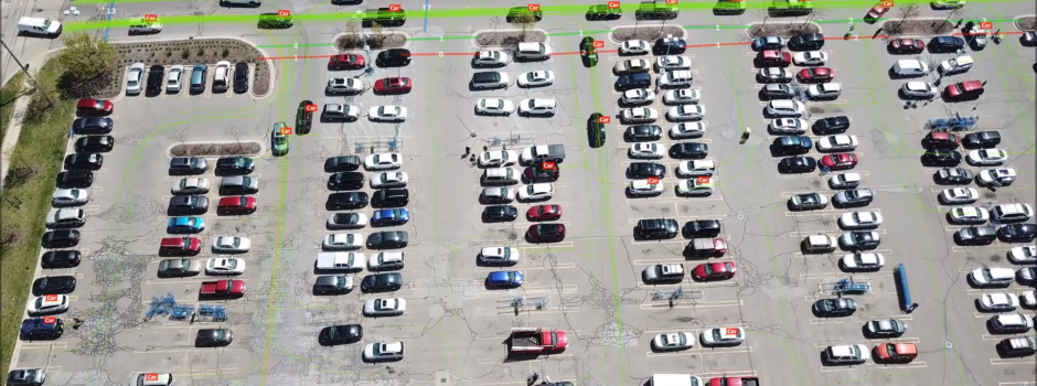
The use of drones is becoming increasingly useful when conducting parking studies, utilizing far less manpower, while collecting more comprehensive data compared to standard methods. The drone video survey can provide additional insights into site conditions that would not be captured otherwise, such as queueing or illegal parking. Short sample of such study using DataFromSky is demonstrated by the following video:
For fixed long-term monitoring of the occupancy of a parking lot in real-time, we at RCE have developed Parking Detection – Technology for Smart Cities.
ParkingDetection is a new and unique smart parking system using AI, that overcomes the limitations of traditional methods of parking management such as inground sensors or overhead sensors. No need for costly pavement work or ground installations! Under the ideal conditions, one smart camera can monitor up to 400 parking spaces at once!
What can Parking Detection offer?
– provides information of individual parking places – real-time occupancy evaluation including vehicle classification
– detects parking rules violations
– supervision of payment discipline – possibility to connect with payment machines
– allow defining your own parking rules, for example:
a rule for maximum parking time
a rule for the types of vehicles that can stand in chosen space
– integrates LED info panels and navigates the driver to free parking space
– provides an intuitive web interface for parking management
– offers advanced statistics and reports
– includes a mobile PD application for drivers – navigation to a free parking spot, availability of free spots, payment, personal vehicle monitoring (the driver is informed through our app, if the vehicle is being manipulated)
– app for car park operators or police for better management and supervision of the car park
Follow ParkingDetection on our social media and keep up with us: Facebook, LinkedIn or Twitter!

Read more