

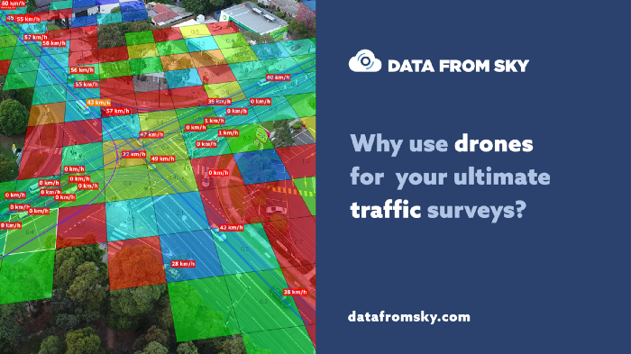
Bird’s eye view is mathematically ideal when it comes to localization of ground targets. In this case a camera has the highest sensitivity even with changing of object position within the image. With growing incidental angle, this sensitivity decreases rapidly. This is the reason why it is not possible to acquire highly accurate data with cameras located alongside the road. Another advantage of the bird’s eye view is with natural minimization of object alignments and occlusions, making the metering even more accurate as the objects are always clearly visible. With this type of camera view, localization accuracy of a vehicle reaches up to 15 cm, with the measurement error under 2% and measuring to 30 cm in dimensions (according to the configuration). If you want extremely accurate not only in counting of object in classes (O/D matrix, TMCs), but also in telemetric data (speed, acceleration, object size), the bird’s eye view is a perfect option. With this accurate telemetric data, it is possible to detect dangerous situations, calibrate models of driver behaviour or even count the capacity of crossroads and much more.


Up to 250 000 m² of covered area
With only a single flying camera/drone, it is possible to cover an immensely large area. From the altitude of 120 meters, you can monitor a road section of up to 250 meters in length. With 300 meters of altitude, you can cover up to 700 meters of the road, and that is a very decent area of monitored traffic area! To acquire image data even from very large traffic corridors, it only takes one device. This is why DataFromSky gives you the most detailed analysis for every single participant of the traffic flow you measure.
Installation within a few seconds
It is definitely not easy to prepare and carry out a traffic research, especially in case of a larger intersections, as you have to install a sensor device for every single mouth of the intersection. You also have to deal with mounting, power supply and on top of this, even protect the device against robbery or vandalism. What you usually get is a series of outputs, which have to be interconnected into one coherent output, which is a very complicated and tedious process. This is not the case if you choose to use a drone for your research! All it takes to analyze the given traffic flow is to fly above the section you are interested in, and make only one video-recording, which contains everything you will need. If your project requires recordings for longer period of time, a drone can be supplied with a cable or you can swap a few drones to get the job done and give you the data you need.

An ultimate solution
A video from the bird’s eye view is the cutting-edge solution also when it comes to richness of acquired data. With one take, you get microscopic data from the whole intersection. AI and smart tracking algorithms then convert the video output into an extract with super-accurate trajectories within the individual classes. With data like this, you can answer even very complex traffic research questions, such us: What are the bottlenecks of the traffic flow? Where do the conflict situations take place? What is the capacity of the intersection? How much time do the vehicles need to cross the intersection in its various parts? How many vehicles have breached the speed limit? Where do the pedestrians usually cross it?