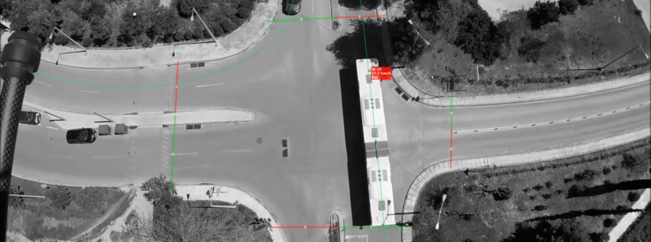
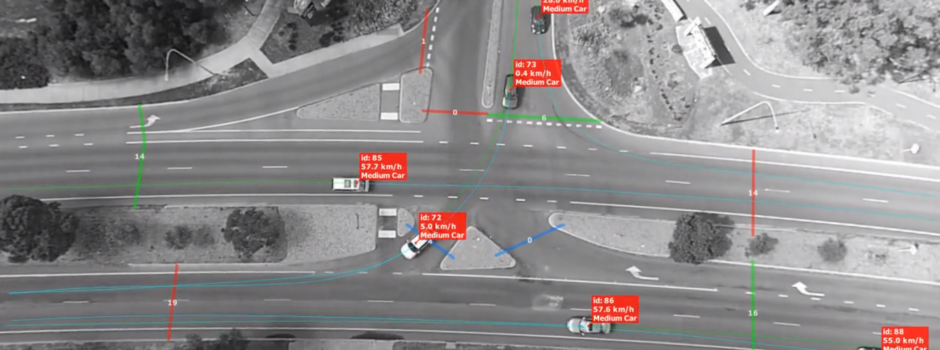
TrafficSurvey – Video post-processing platform
You probably remember the recording in Venice: Blimp recording in Venice, Recording in Venice in detail. We have obtained permission to share some of the results, so we can show you what can DataFromSky do for you, too!
The speed profiles for both areas were extracted.
At a glance, one can see what speeds belong to which path through the crossroads. It is also plainly visible which trajectories belong to slow and which to speedy drivers. In this case, the total area captured and analyzed is too small to show bigger changes in speeds, though.
Density of trajectories corresponds to area usage. One can thus estimate how much of the road’s width is actually used by passing vehicles, and where the wear of roadway is most intensive.
DataFromSky can detect situations where vehicles become too close, or have to slow down to let each other pass. This is a visualization of these events’ spatial distribution. You can easily see that there is a single point for the T-intersection and estimate from the pattern at roundabout that its southern leg is far less used.
Deflection angle denotes the part of road which requires circular movement. Radius describes the size of that circle. Both can relate either to the shape of road, or actual trajectory used by vehicles.
DataFromSky provides real vehicle trajectories, so actual deflection angles and radii can be measured. These depend on the combination of entry and exit points, so it’s natural to split the trajectories into groups. Again, with DataFromSky you are not left wishing for features.
Last but not least, the trajectory data from DataFromSky is exactly what you need to validate design of the road. Whatever the design process, verifications, and modelling tell you before, here you get real data about the situation.
Pictures used in this post are only illustrative and do not match the text perfectly. All trajectories are visualized, instead of particular groups.
Read moreWe are pleased to announce our exciting new partnerships with UAV640, ATEC-3D, Airpixa, and Telink to distribute DataFromSky solution within European Union. Welcome on our board!
UAV640 is a French company based in Bayonne. The tagline on their website, “drone and dirigible services for industry“, is a very brief way of describing what they do.
UAV640 has a number of rotary wing drones, two independently manoeuvrable miniature airships for larger payloads, and a tethered baloon. The wide range of types is ideal for traffic monitoring purposes, providing hardware for both shorter and longer studies.
Apart from deploying a diverse fleet of aerial vehicles, UAV640 has a training centre for UAV operators and a lab.
ATEC-3D is a British UAV operator. Currently, their focus is on aerial photography, mine surveying, inspections and environmental usage. We hope to work together on traffic analysis in future, too!
Airpixa is a British UAV operator. From their site: AirPixa specialises in photography and engaging corporate video productions with a special emphasis on aerial work.
Again, we are looking forward to working together on traffic analysis…
Telink is a Czech company providing sales, repairs and renting of UAVs.
An article about us appeared in Czech e-magazine E15.cz. This is a result of a visit by Jan Sedlák a few weeks earlier. E15.cz focuses on IT commerce and is part of portfolio of Mladá fronta, one of the biggest publishing houses in Czech republic. Needless to say, we are pleased to be covered by them!
The article itself mostly just skims on the surface of DataFromSky as a solution, as is to be expected from an article of this length. You can learn something about the business situation of RCE Systems, our company, though.
As a reminder – we are ready to process short (ca. 5 minutes) video clips as a demonstration of our service. For this we need:
For more information about recording video usable with DataFromSky, please read the document “Recording video for DataFromSky”.
We will give you the results of analysis, which can be viewed in the freely downloadable version of viewer / trajectory analyzer. We are looking forward to showing you what DataFromSky can do!
Read moreA series of recording happened around Venice in recent days. A big difference from our “traditional” quadcopter-based approach was the vehicle used for carrying the camera: a tethered blimp.
This pilot project involved TAU, TrafficLab and S8 Esseotto.
The blimp visited three crossroads around Venice, recording from height of 40-70 meters a total of 4.5 hours or 270 minutes of traffic footage for analysis. The weather was somewhat disfavourable, with strong gusts of wind. The results turned out excellent, though.
Analysis of the videos is underway.
The number of partners has increased in the recent days by four with TAU, Sky Eye Innovations, University of Palermo and Department of Mechanics, Energy, Management and Transportation Engineering at University of Genova.
TAU is a short for Trasporti e Ambiente Urbano s.r.l. The Milano-based company provides turn-key traffic analysis services, using its helium-filled balloons for recording video and DataFromSky as a subcontractor for processing and analysis.
Sky Eye Innovations is a Swedish company based in Stockholm, focusing on production and renting of custom-built UAVs. They will offer video recording services and distribution of DataFromSky.
Professor Gianfranco Rizzo from University of Palermo is working on advanced research into transportation – now with help from DataFromSky, too.
Department of Mechanics, Energy, Management and Transportation Engineering at University of Genova becomes another of our academic partners.